

Historical Sites
History Hits videos on some of the New Forest’s best historical sites.
The New Forest has a long and proud history that dates back almost 1,000 years. It takes its name from the Latin ‘Nova Foresta’, which translates literally as ‘new hunting ground’, although hunting had been going on in the area long before this time.
Find out about some of the most interesting and significant historical sites in the National Park through the bite sized History Hits and drone videos in this section.
Ashley Walk bombing range
Ashley Walk is a historic area of open heathland in the north-west of the New Forest, shaped by centuries of grazing, woodland management and military use. Once used as a World War I airfield and later for military training, the landscape has since been restored and is now valued for both its wildlife and its sense of openness. Today, Ashley Walk is a peaceful place to explore, offering a glimpse into how the Forest’s land has been continually adapted and reused over time.
Beaulieu Airfield
Beaulieu Airfield was constructed during the Second World War as part of Britain’s wartime defence network. Opened in 1942, it played a key role in supporting Allied air operations, particularly in the lead-up to D-Day. Although the airfield was dismantled after the war, traces of runways and infrastructure remain visible in the landscape, quietly reflecting the Forest’s strategic importance during a critical moment in history.
Bronze Age Barrows
Scattered across the New Forest are hundreds of Bronze Age barrows — ancient burial mounds dating back over 4,000 years. These low, rounded earthworks are some of the Forest’s oldest visible archaeological features and offer evidence of early human settlement and ritual activity. Their survival within the open landscape highlights the Forest’s long history as a place of significance long before it became a National Park.
Buckland Rings
Buckland Rings is one of the best-preserved Iron Age hillforts in southern England. Surrounded by multiple earthwork banks and ditches, the site once served as a defensive stronghold and centre of community life over 2,000 years ago. Today, the dramatic earthworks are still clearly visible, offering insight into prehistoric life and the strategic use of the landscape.
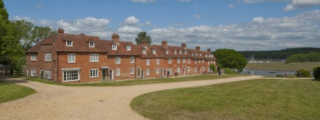
Buckler's Hard
Buckler’s Hard is a unique village with an interesting history where 18th and 19th century cottages almost unaltered, line either side of a wide central street leading down towards Beaulieu River.
The east terrace is made up of a series of linked buildings dating from the 18th century and very early 19th century. There were originally two inns, Ship Inn and New Inn. The western terrace of buildings is also a series of linked buildings, dating mainly from the 19th century. All the buildings are constructed of local handmade red brick with clay tiled roofs.
The settlement dates from the 1720s when it was laid out as a planned town by John, 2nd Duke of Montagu.
He intended it to be a free port for the import and export of sugar from the West Indies where he was intending to develop colonies and sugar plantations. The settlement was to be called Montagu Town and was laid out in symmetrical blocks of land, either side of the 80 foot wide street designed to be used for fairs and markets. A prospectus was issued offering plots of land on a 99 year lease for 6/8d. However, the Duke’s colonising enterprises failed and by 1731 only seven houses had been built.
In the 1740s the Navy Board were looking for suitable sites for the construction of fighting ships and the settlement became a civilian shipyard. In 1744 Henry Adams was sent by the Navy Board as the resident overseer seconded to supervise the building of the 24 gun ‘Surprise’. He married a local girl and took on the tenancy of the ship yard. He built several war ships for the seven years war which lasted from 1756 to 1763.
In 1771, Adams constructed longer launch ways so that 64 and 74 gun war ships could be built. The Adams family continued building war ships until 1814 and then turned to the construction of small cutters and merchant ships until 1847 when the family gave up the tenancy of the shipyard.
Henry Adams built himself a large house, now The Master Builder’s House Hotel, at the end of street, overlooking the slipways. Most of the other houses in the street were constructed in the mid and late 18th century when ship building was at its height. By the 1851 census, only one elder shipwright lived at Buckler’s Hard and the village went into decline becoming a small agricultural community supporting the activities of the Beaulieu Estate.
At its height in the early 19th century the settlement contained nearly 40 houses, but in the second half of the century, many houses were demolished.
Beaulieu River became a magnet for yachtsmen and pleasure boats in the early 20th century. In 1866, the river came into the ownership of Lord Montagu and in 1927, the first official Harbour Master was appointed to regulate river traffic and collect mooring fees.
During World War II, Beaulieu River was closed to private yachts and Buckler’s Hard became a repair facility for the Navy. To start with, it specialised in fitting out wooden mine sweepers and repairing the wooden motor torpedo boats. Houses in the village were requisitioned for Navy personnel and it became a base for the construction of dummy landing crafts for the secret ‘Operation Quicksilver’.
Later in the war, in support of the D-Day landings, over 50 concrete pontoons for the Mulberry Harbour were built on a site just downstream of the village. A concrete floating dock was also constructed; this was large enough to hold a tank landing craft. Beaulieu River and Buckler’s Hard played a big part in the build up to the D-Day landings with many craft and thousands of Army and Navy personnel gathered in the area.
After the war, the area once again became popular with yachtsmen. The Agamemnon Boat Yard was opened in 1947 as a repair facility for private yachts and 150 moorings were laid in the river. In 1963, Buckler’s Hard Maritime Museum was opened in what had been the New Inn. Visitor numbers grew rapidly to 250,000 a year and the Estate became very concerned about the effects of visitor pressure on the historic environment.
In the late 1960s, a conservation plan was commissioned for the area to address this visitor pressure. As part of the plan, a new 76 berth marina was constructed just up river and in 1971 the street itself was closed to traffic and larger car parks developed to cope with visitor parking.
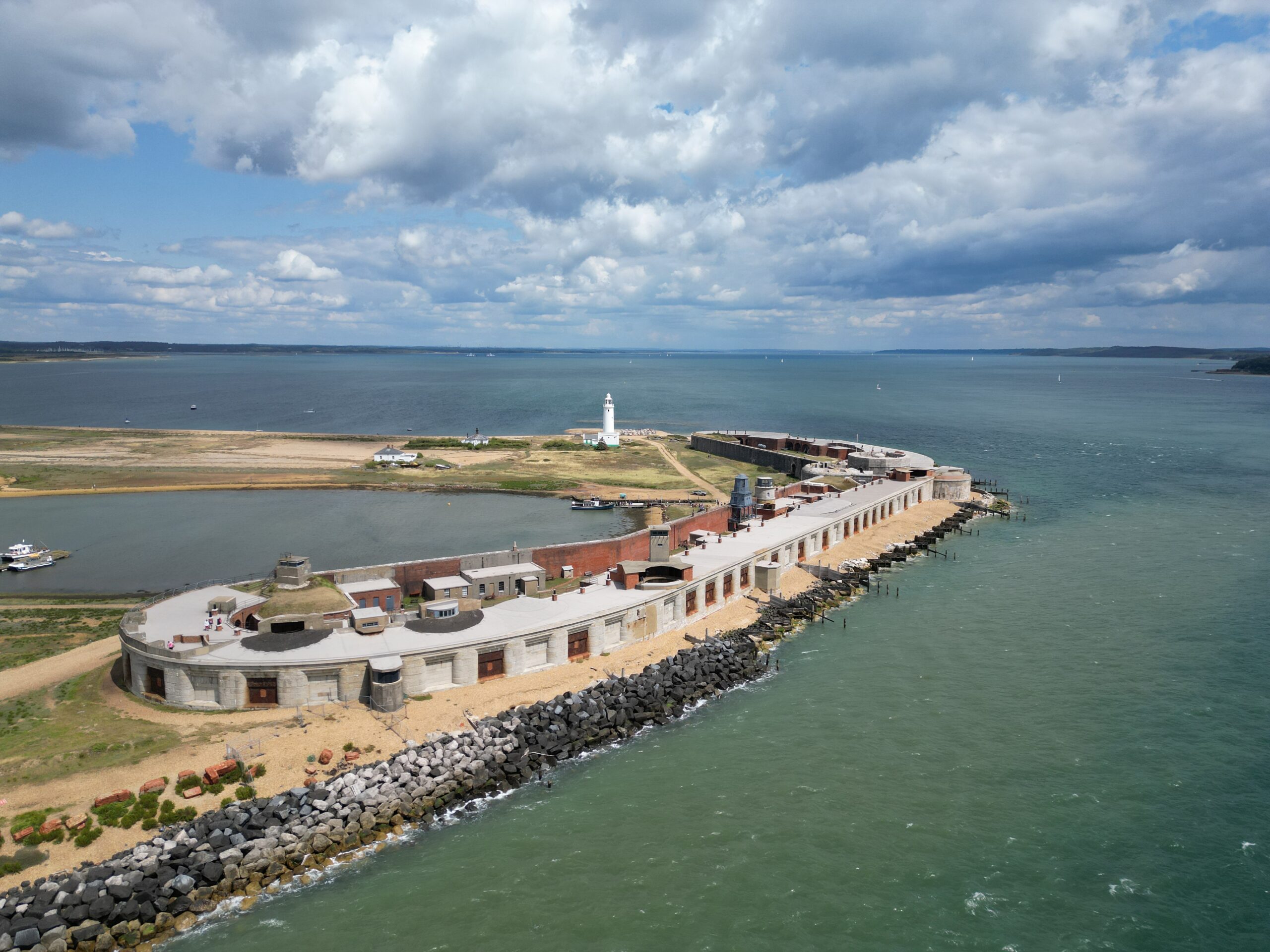
Hurst Castle
Hurst Castle, an English Heritage property managed locally by Hurst Marine, is at the seaward end of the shingle spit that extends 1.5 miles from Milford-On-Sea – and offers a great day out in the New Forest.
This artillery fortress, built by Henry VIII, provides one of the best views in England. Commanding the entrance to the Solent, its strategic location has developed the castle into a powerful fortress, steeped in centuries of military history.
From its beginnings in 1544, as one of Henry VIII’s chain of artillery defences Hurst Castle, unusually for a Tudor castle, remained in military use until 1956, playing an active role through both world wars. Occasionally it was also used as a prison, most famously in the imprisonment of Charles I in the 17th century, during the Civil War. Hurst Castle defended England from invasion threats in the 19th and 20th centuries and exhibitions around the castle will provide you with an opportunity to learn more about its long history.
With spectacular views of the Solent and the Isle of the Wight from the top of the Tudor Keep and plenty of open spaces for children to explore, it’s a great day out for the whole family. Dogs on leads are very welcome too.
Access to Hurst Castle is a leisurely ferry ride from Keyhaven (charges apply) or a two-mile walk along Hurst Spit (please note this is a shingle spit).
Castle highlights include:
Its Tudor fort, which retains much of its 16th century appearance.
The Tudor keep, where it was probably here that Charles I was kept prisoner in 1648.
Spectacular views from the roof of the Tudor keep across the Needles Passage to the Isle of Wight.
The basement of the Tudor keep, used for storage of food, fuel, weapons and gunpowder.
The Garrison Theatre, possibly the last theatre constructed by the garrison to survive from the Second World War.
The lighthouses on the spit within the Lighthouse exhibition in the West Wing, from the first light built in 1786 to the High Light of 1867, which still functions today.
For more information visit hurstcastle.co.uk
Keyhaven salterns
The Keyhaven salterns are the remains of a once-thriving salt-making industry that operated along the coast for centuries. Salt was an essential commodity for food preservation, and the network of pans, channels and embankments reflects the ingenuity of early coastal industries. Although salt production has long ceased, the area is now an important habitat for wildlife, showing how industrial heritage and nature coexist in the New Forest.
Lepe D-Day Remains
Lepe Beach was a key embarkation point for Allied troops and vehicles during the build-up to D-Day in 1944. Concrete slipways, seawalls and other remains still visible today were constructed to support the loading of tanks and supplies onto landing craft. These remnants offer a powerful reminder of the Forest’s role in one of the most significant military operations of the 20th century.
Medieval Hunting Lodges
During the medieval period, the New Forest was a royal hunting ground, and hunting lodges were built to accommodate monarchs and their courts. These lodges served as bases for managing the Forest and hosting hunting parties, reinforcing its status as a place of privilege and control. Though many survive only as ruins or place names, they reveal how power and land use shaped the Forest’s history.
Napoleonic Rifle Range
The Napoleonic Rifle Range reflects the New Forest’s role in Britain’s coastal defence during the early 19th century, when fears of invasion by Napoleonic forces were high. Used for military training and weapons testing, the site forms part of a wider defensive landscape along the south coast. Its remains offer insight into how national security concerns left lasting marks on the Forest.